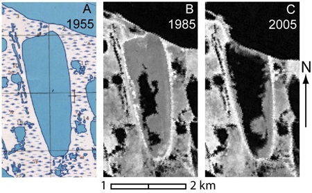
The U.S. Geological Survey (USGS) has completed a new study of coastal erosion in the Northeast portion of the National Petroleum Reserve-Alaska (NPR-A). The study used topographical maps from 1955 and satellite infrared data from 1985 and 2005. The comparisons found coastal erosion in the 70-mile area that was studied has doubled in the last 50 years. John Mars was the lead author of the USGS study. He said an exploratory well drilled in the 1970s called the J.W. Dalton site showed alarming erosion that needed closer examination.
There are 28 wells in the area that were drilled by the USGS in the 1970s to delineate the NPR-A oil reserves. The Bureau of Land Management is working on a plan now to clean up three of the wells they have determined to be of most concern. Wayne Svejnoha, an environmental manager for BLM, says the wells and drill waste pits contain a mixture of liquids, including some petroleum products.
- Report summary
- Report slide show (requires Flash plug-in)
- Report sample images
Lori Townsend, APRN – Anchorage


