The Earth’s crust is more flexible than you think – especially in Southeast Alaska. Growing and shrinking icefields and glaciers, and rising and falling oceans have altered the region’s coastline over time.
Understanding those changes is helping scientists learn more about the area’s early human habitation. A Southeast geologist talked about what’s been discovered during a Nov. 25 Sealaska Heritage Institute Native American Heritage Month lecture.
We’ve all pretty much grown up with the assumption that the land we live on is when it’s been for thousands of years.
Sure, we have volcanoes and earthquakes and, if you paid attention in school, plate tectonics. But the big stuff happened millions of years ago, right?
Wrong. In this part of the world, drastic changes have happened in the past 6,000 to 15,000 years.
Forest Service Geologist Jim Baichtal explains.
“The ice came out on the landscape. It pushed down on that land. The sea reinvaded as the ice started to melt. And now that land has risen up,” he says.
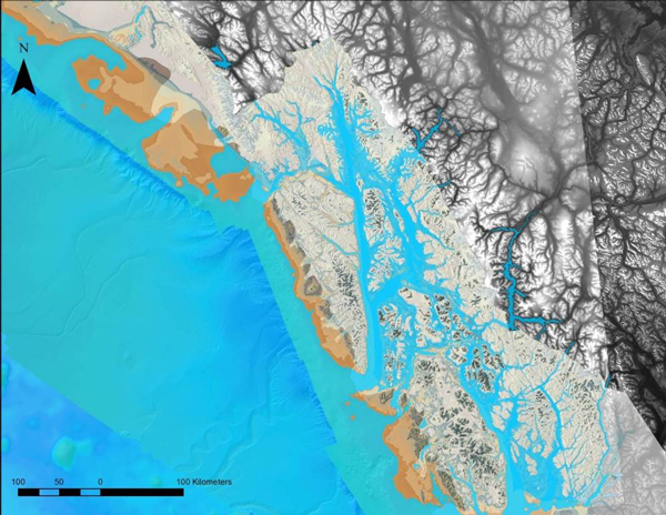
He knows that because he – and others – have been mapping shell beds. They’ve been found from below today’s shorelines to hundreds of feet above.
Once you figure out where the shore used to be, you can make an educated guess of where early inhabitants lived – and what they saw.
“If you and I would have been, 10,000 years ago, on the shoreline and we lived to be 50 years old, sea level would have risen 10.2 feet in our lifetime,” he says.
And that matches some oral history.
Some of the settlements moved up and down rivers and streams as the ocean rose and fell, flooding coastal waterways, then receding.
Scientists have found campsites with tools and other signs of occupation.
Baichtal says they include agate and obsidian, which is only accessible in a few areas.
“So these people had been on the landscape long enough to find all those sites, and develop trade back and forth from those sites throughout all of Southeast Alaska by 10,500 calendar years ago,” he says.
The findings have larger implications for the region’s human history.
For example, Baichtal says flooding could have made it easier for early inhabitants to travel.
“So [when] people were coming into Southeast Alaska, they might not have been paddling down rivers. They were coming down the fjords,” he says.
And once here, travel would have continued on the water.
“Admiralty Island was a multitude of islands. If you look at the Cleveland Peninsula, it was a multitude of islands. The same [is true] for Gravina Island and Annette Island outside of Ketchikan,” he says.
Baichtal and other scientists have continued expanding their discoveries. He says before 2009, only five early settlement sites had been located. Since this type of research began, 17 more have been added to the list.
Excavation has also provided a look at Southeast Alaska’s climate history.
“Throughout 10,000 years to about 6,000 years, I’ve got a lot of evidence out of these muds that suggests that we were as much as 3 to 4 degrees Fahrenheit warmer, with half the rainfall, and that fire was part of our ecology,” he says.
Baichtal says weather patterns settled down around 5,500 years ago. That’s when human settlements really began to grow.
“The sea level balances, fish probably started getting established in big numbers in the streams, the streams no longer were being as dynamic and down-cutting and the sea level was no more rising, and I think people began to greatly flourish at that time,” he says.
As they’ve found more sites, Baichtal and his fellow scientists have developed more detailed maps of past Southeast coastlines.
He says other coastal areas could do the same.
“I’m sure all the way along the Gulf of Alaska, when you get out to Kodiak and up north, the same processes are going on. We’ve just not taken a look at applying this strategy on the landscape,” he says.
Another type of early settlement research still needs to be undertaken.
That’s exploration below current tidelines. Researchers in nearby northern coastal British Columbia have found evidence of settlements – 300 to 500 feet below the ocean’s surface.
Ed Schoenfeld is Regional News Director for CoastAlaska, a consortium of public radio stations in Ketchikan, Juneau, Sitka, Petersburg and Wrangell.
He primarily covers Southeast Alaska regional topics, including the state ferry system, transboundary mining, the Tongass National Forest and Native corporations and issues.
He has also worked as a manager, editor and reporter for the Juneau Empire newspaper and Juneau public radio station KTOO. He’s also reported for commercial station KINY in Juneau and public stations KPFA in Berkley, WYSO in Yellow Springs, Ohio, and WUHY in Philadelphia. He’s lived in Alaska since 1979 and is a contributor to Alaska Public Radio Network newscasts, the Northwest (Public Radio) News Network and National Native News. He is a board member of the Alaska Press Club. Originally from Cleveland, Ohio, he lives in Douglas.


