Alaska has 33,904 miles of coastline, more than the rest of the United States combined. For a long time, there has not been much information available to researchers or to the public about that shoreline and about the wildlife habitats that exist there. A new project gives people the ability to research and explore the coast from their computers.
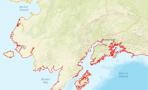
ShoreZone is a project that provides photo and video footage of the coast of Alaska. It passed a benchmark last month—imagery of more than 90% of Alaska’s coast is publicly available online. It is sort of like Google Earth Street View, but for the coast.
The project began in British Columbia in the 1970s. It came to Alaska in 2001. Kelly Ingram is the ShoreZone Partnership Coordinator for the Nature Conservancy.
“We’re able to fly and see images from the coastline and then see a ton of other data about the habitat, the sub-strait, wave exposure, erosion potential… a whole lot of other data,” Ingram said.
In order to map the coast, a team flies in a helicopter at low tide. They fly 300 feet off the ground and 300 feet from the shore at 80 miles per hour. A photographer takes photos every 3 seconds, and another crew member takes video.
There are a variety of uses for such imagery.
“First off, it provides a baseline inventory of the coastline,” Ingram said. “This really provides really detailed information about fishing about the geology and the species that are there along our coastlines that can be used for oil spill response planning. It can be used for looking at climate change and how things are being affected along our coast. It can be used to look at fish habitat areas. Or it can be used to plan your kayaking trip or if you’re going out fishing on your boat or something like that.”
The remaining 8% of Alaska’s coast that ShoreZone has yet to map is going to be difficult terrain, says Ingram, but teams are at work on it right now.
David Ward is a wildlife biologist with the U.S. Geologic Survey and the Alaska Science Center in Anchorage. He uses ShoreZone in his research in Southwest Alaska. Ward maps the distribution and abundance of eelgrass in the Yukon Delta, Togiak, Isenbeck and Alaska Peninsula National Wildlife Refuges. The primary means of mapping used to be done by Landsat imagery and field surveys. But ShoreZone has filled in some of the gaps from that data.
“So it helped us to supplement areas where we lacked efficient data for mapping, or it further helped us to refine our mapping of eelgrass in those areas,” Ward said.
ShoreZone photographs, video footage, and data are free and available online at ShoreZone.org.


