Heavy snow over the weekend in parts of Southcentral Alaska has forecasters urging caution in the backcountry due to heightened avalanche danger.
Wendy Wagner, with the Chugach National Forest Avalanche Information Center, said the avalanche danger in the area is still high.
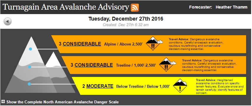
“Statistically speaking, the considerable danger happens after a storm,” Wagner said. “This is when the most fatal avalanche accidents occur.”
Wagner said that’s because the calm after the snowstorm can lure people into a false sense of security.
And especially with Turnagain Pass recently opening to snowmachines for the season, Wagner urged backcountry users to stay out of avalanche terrain.
“Because we do expect snowmachiners and skiers to be able to trigger large avalanches,” Wagner said. “And these are the dangerous kind; these are three feet deep and they can bury and kill a person.”
Wagner said the general rule of thumb is to let the snow settle for about two days after a storm before venturing out into the mountains. But for this storm, she said it needs more time.
“That old surface was really weak; that snow is like a layer of marbles sitting on the mountain,” Wagner said. “So we are expecting the snowpack to take a week, potentially.”
Wagner said hazardous conditions are likely to persist until the next snowstorm rolls through. The weak snowpack, however, is not limited to the Chugach.
Jed Workman, with the Hatcher Pass Avalanche Information Center, said a thin base layer of snow and varying weather conditions have set a dangerous precedent for the rest of the season.
“The early season snowpack that came in October rotted-out due to cold, calm, clear conditions, and that will be a persistent weak layer for the entire season,” Workman said. “All the snow that comes from now until the end of the season will be sitting on that very weak base and it’s not something that’s just gonna go away.”
Predicting the weather in Hatcher Pass, particularly for precipitation, is difficult. But, Workman said the avalanche information center will be getting some reinforcements in late January, as the National Weather Service adds the area to its recreational forecast.
“It means we’re gonna a higher level of accuracy and more regular information about the weather for that very specific area,” Workman said. “They’re gonna put a higher level of attention to it.”
NWS already produces a recreational forecast for the Chugach Range and Thompson Pass, giving area- and altitude-specific information for snowfall, temperature and wind.
So far, it’s been a very dry winter for Hatcher Pass. If the weather pattern changes, though, and the area gets a big dump of snow, Workman said avalanche conditions would worsen dramatically.
“It would get scary really fast because of this deep, persistent weak layer at the base of the snowpack,” Workman said.
And Workman emphasized that there are some big differences between the snowpack in Hatcher Pass and the snowpack in the Chugach.
“Hatcher Pass is more like Colorado; it has a very weak snowpack, generally speaking, and it can be safe to play in, but when there are problems they tend to stay for a long time and they’re not always easy to discover or evaluate,” Workman said. “Whereas in the Chugach it’s more of a maritime snowpack; instabilities come in, and they are problematic for a day, a week, but then they heal.”
Storms and new snow are predicted later in the week for both Hatcher and Turnagain Pass.
Josh is the Statewide Morning News Reporter/Producer for Alaska Public Media | jedge (at) alaskapublic (dot) org | 907.550.8455 | About Josh


