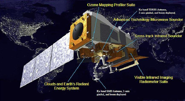
The federal government is scheduled to launch a new satellite later this month that will improve weather forecasts. JPSS-1 is a polar orbiting satellite that tracks dozens of things like temperature, moisture, snow cover and even wildfires.
Brian Brettschneider, with our Ask a Climatologist segment, is eagerly awaiting the new images and data from the new satellite.
He says it will orbit pole-to-pole, crossing the equator 14 times each day.
Interview Transcript:
Brian: And that provides, at any given location, at least two snapshots per day of what’s going on in the atmosphere at that location.
Annie: Why is that important, especially for the far north?
Brian: Many people are familiar with seeing satellite images, say of hurricanes, we saw that a lot this summer. And those come from geostationary satellites. They’re orbiting at 22,500 miles above the equator and they circle the earth at the same rate the earth rotates. But they have to be over the equator. So here at Alaska/Arctic latitudes, we’re out of the range of those satellites. Maybe in Southeast, they’re caught a little bit, but north of 60 degrees, which is mainland Alaska, we’re not in that. So we rely on other satellite imagery, geosynchronous orbit and some other satellites that don’t catch us as frequently and when we’re at an oblique angle. So having something that rotates a couple times a day, that’s going to get us higher resolution information is very important for forecast modeling and environmental modeling.
Annie: This isn’t just about forecasts. How do satellites help inform policy?
Brian: The first weather satellite was launched in 1966. We use that as a benchmark for environmental monitoring, whether it’s for hurricanes, whether it’s for sea ice, whether it’s for ozone. All these things we assume we have this long, robust record for, but before the satellite era for many things it was very fragmented. We have records for coastal sea ice going back a long way. We have records of hurricanes striking the lower 48 a long time ago. But we don’t have this uniform distribution across space until we have satellites. So a lot of the decisions we make from a public policy standpoint that involve environmental and earth science data, really we start with the satellite era. And as we get better and better satellite imagery, we have more information to make good public policy decisions.
Annie: Are you looking forward to seeing these first images?
Brian: It’s kinda like being a kid in a candy store. There’s all kinds of fascinating information that you can see from it. From the first generation satellite that’s out there, from events where we have strong northerly cold outbreak, you can see silt blowing off of glaciers, you can see ash being blown off volcanoes, previously deposited ash, so there’s always something new and fascinating that you’ve never seen before when there’s a new generation satellite that’s launched.
Annie Feidt is the broadcast managing editor at Alaska Public Media. Reach her at afeidt@alaskapublic.org. Read more about Annie here.


